Watermead Country Park South
Watermead Country Park is a network of lakes woodlands and nature reserves created from 340 acres of gravel workings along the River Soar to the north of the city.
Watermead Country Park is now a haven for wetland wildlife enjoyed by nature lovers, walkers and families. The park has fine lake views and woodland walks with good paths and picnic areas.
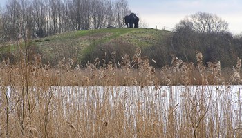
A life sized sculpture of a mammoth inspired by the mammoth, bison and deer bones found in the gravel workings overlooks the 92 acres of Watermead managed by the City Council. Further north the park is under the control of Leicestershire County Council.
Easily accessible either on foot or by bicycle the Sustrans long distance cycle route 6 and local route 1 cycle ways passes through the park.
Facilities
- Animal sculpture information
- Mammoth sculpture
- Play area
- Car parking available - card payments only (pay and display) - find out about parking charges
How to find us
Leicester, LE4 7RN
Contact us
Ring us on: 0116 454 1003
Send us a message
Printable visitor guide and map
Please note the visitor guide and trail map is not designed for viewing online but for downloading and printing. If you have problems accessing or viewing the guide, please email parks@leicester.gov.uk.