Transforming Cities Fund Projects
Forthcoming Transforming Cities Fund (TCF) projects which are currently being developed.
- New city centre electric bus service linking all transport, retail, employment, educational and hospital hubs to provide quick and easy access
- Improved frequency and electrification of two park and ride bus services to provide car drivers a real alternative choice to driving into the city
- Bus priority measures delivering improved frequency for the Enderby Park and Ride service (and other commercial services) reducing the current journey time for users.
- A new park and ride service/interchange at Beaumont Leys District Shopping Centre, supporting existing commercial routes into the city centre to provide more travel choice
- New electric park and ride service from Beaumont Leys to Glenfield Hospital providing easy access to the hospital
- Breaching the Central Ring Road and delivering connectivity to corridors in North, South and West of the City Centre
- Bus demonstration corridors and priority measures in North West/South West sectors of city boosting speed and reliability.
- High quality cycling and walking infrastructure in North West/South West sectors of city.
- A neighbourhood cycling and walking scheme in Beaumont Leys to deliver neighbourhood level enhanced connectivity and transport integration.
- Smart ticketing via contactless bank cards and mobile phones integrating all bus operator systems
- Real time information at all main bus stops and improved waiting facilities on priority bus corridors
- Improved waiting facilities at bus stops
Projects
Below are details of the project we propose to deliver as part of the TCF programme. If you wish to comment on any of the projects before the deadline shown in the text for each project, please email [email protected].
Started on site in late March, Leicester City Council is undertaking a cycling infrastructure improvement scheme on Bennion Road, including:
- Segregated unidirectional cycle lanes along both sides of Bennion Road between Anstey Lane and Beaumont Way.
- Ramps to allow cyclists to safely join and exit the cycle lanes at the bus interchange in order to safely take them on a short section behind the bus shelters.
- A new toucan crossing on Bennion Road on the approach to the Beaumont Way roundabout.
- New crossing facilities for cyclists and pedestrians on Beaumont Way on the approach to the Beaumont Way roundabout.
- Alteration of the existing 2-lane carriageway on Bennion Road’s approach to Anstey Lane roundabout, to accommodate the proposed cycle lanes, and with the option to convert one lane into a bus lane in the future.
- Relocation and re-engineering of existing bus shelters at the interchange, to allow passengers to safely alight from buses and cross the cycle path.
The scheme is progressing well and will be moving to the next phase which will include the following:
- Segregated unidirectional cycle lanes along both sides of Bennion Road between Orwell Drive and Beaumont Way.
- A new toucan crossing on Bennion Road on the approach to the Beaumont Way roundabout.
- A new toucan crossing facilities for cyclists and pedestrians on Beaumont Way on the approach to the Beaumont Way roundabout.
Diversions
Traffic Management will be in place and there will be a number of diversions as shown below (notes: these dates are subject to change):
Bennion Road
At its junction with Anstey Lane to its junction with Orwell Drive.
Restriction:
- Prohibit the Movement, Waiting and Loading of All Vehicles
- From 6am to 5pm Sunday 21 May 2023
Diversion: Orwell Drive, Krefeld Way and Anstey Lane
Beaumont Way
At its junction with Bennion Road to its junction with Rutherford Road.
Restriction:
- Prohibit the Movement, Waiting and Loading of All Vehicles (Eastbound Only)
- From 7am Monday 22 May 2023 to Sunday 19 June 2023
- Pedestrian access to be maintained
Diversion: Bennion Road, Orwell Drive, Rutherford Road
Beaumont Way
At its junction with Bennion Road to its junction with Rutherford Road.
Restriction:
- Prohibit the Movement, Waiting and Loading of All Vehicles (Full Closure)
- Sunday 18 June 2023 to Sunday 2 July 2023
- Pedestrian access to be maintained
Diversion:
- Bennion Road, Orwell Drive, Rutherford Road
- Beaumont Way, Orwell Drive, Bennion Road
We working with Sustrans, Leicestershire County Council, Blaby District and Braunstone Town Councils plan to jointly invest around £1.2million in a range of improvements to create a safer and more attractive route for pedestrians and cyclists between New Lubbesthorpe, Thorpe Astley and nearby Meridian Leisure Park, in Blaby, and Leicester city centre.
The scheme will be backed by over £600,000 of funding from the Leicester and Leicestershire Enterprise Partnership (LLEP) through the Leicester and Leicestershire Business Rates Pool fund. We have has also been successful in securing an additional £450,000 funding from the Department for Transport’s Paths for Everyone scheme with our delivery partner Sustrans.
The proposals will involve a range of improvements to create a safer and more attractive route for pedestrians and cyclists linking New Lubbesthorpe, in Thorpe Astley, and nearby Meridian Leisure Park, in Blaby, with Leicester city centre.
The scheme will consist of six sections as follows:
Murby Way to Foxon Way
- Widening the footpath from 1.5m to 3m between the Murby Way and Foxon Way roundabouts
- Narrowing of road crossing distances at the roundabouts at Murby Way and Foxon Way to create safer crossings at these junctions
Meridian Way
- Narrowing of the crossing distances at the northern arms of the 2 roundabouts over A563 Lubbesthorpe Way to help all users cross at these junctions
Mossdale Meadows
- Widening of the footpath from 1.5m to 3m, and vegetation clearance to improve visibility on blind corners to provide an enhanced pedestrian and cycle route
- New access point to the rear of Meridian Leisure Park for pedestrians and cyclists which will be delivered as part of a project coordinated by its owners Savills.
Kingsway
- Creation of new 3m footpath to allow easier access from the western to the eastern side of the Kingsway
- Widening of footpath from 1.5m to 3m in the vicinity of the Narborough Road South underpass
- Creation of new 3m path to provide improved access from the Kingsway to Aylestone Meadows
Aylestone Meadows
- Improvement to the existing boardwalk at Kingsway, to provide a better access to the Meadows for all users
- New 3.5m path across Aylestone Meadows, connecting onto existing track for pedestrians and cyclists
- Resurfacing of existing track to a width of 3.5m, up to Braunstone Lane East. Please note there are also proposals to make the pop-up cycle track on Braunstone Lane East permanent – an initial invitation to comment will be delivered mid- August.
Mill Lane
- Making permanent the pop-up cycle lane, involving widening of the footpath on Western Boulevard
- Providing segregated cycle route on Mill Lane, providing a direct link to De Montfort University campus and Braunstone Gate where work is currently underway on a £1.5million ‘mini-Holland’ scheme.
Work is due to begin in August 2022 and is expected to take around nine months to complete.
You can request plans for this scheme by emailing: [email protected].
We are considering a range of possible improvements as part of our citywide programme of investment to help local businesses recover from the effects of the pandemic and the disruption it caused.
As part of this programme we are looking at improving the shopping environment on Queens Road by creating more space for outdoor café areas and wider, safer pavements for pedestrians.
Initial ideas include possibly making changes to some side road junctions (for example, closing the Montague Road and Cecilia Road junctions to vehicles) to create more pedestrian space and cut the amount of traffic turning into Queens Road.
Pavements could be widened at key points to make more space for outdoor café-style seating areas to support businesses, while retaining the on-street parking spaces for shoppers and visitors, including disabled people. Additional loading bays could be provided for businesses.
This could include widening pavements outside Barceloneta and Friends Tandoori (between Howard Road and Cecilia Road) and filling in the existing bus stopping bay alongside the shopping area between Montague Road and Clarendon Park Road to create more space.
Improvements to make the route safer and more appealing to cyclists are also being considered, to complement the recent introduction of a docking station on Queens Road as part of the new Santander Cycles Leicester e-bike hire scheme.
Traffic calming measures, such as raised crossings, on Queens Road are also being considered to encourage motorists to cut their speed and improve road safety.
The initial ideas for improvements to Queens Road have been developed closely with ward councillors and we are now inviting local residents and businesses to have their say on these initial ideas via our consultation website. Closing date for comments is Saturday 30 July 2022.
Transport improvement works will commence in Autumn 2022 on Fosse Road North (from the Stephenson Drive junction), FiveWays junction, Buckminster Road (to the Colwell Road junction), Woodgate, Northgate Street, Frog Island and Great Central Street. The improvement works will include the introduction of cycle lanes, new/enhanced pedestrian and cycle crossing facilities, and safety improvements at the FiveWays junction. The Introduction of improved pedestrian priority and cycle infrastructure will help encourage active modes of travel and reduce the reliance on private car use, particularly for short distance journeys.
Fosse Road North
- Removal of mini roundabout at the junction with Stephenson Drive and replace with a signalised junction;
- New bus lane with associated signing and lining – may require minor carriageway widening;
- Footway widening to accommodate a segregated cycle lane on the northern footpath;
- Level crossing points across Central Road and Bonchurch Street;
- Improved access to Rally Park.
FiveWays junction (Blackbird Rd/Woodgate/Fosse Rd North/Groby Rd/Buckminster Rd)
- Complete redesign of the junction including removal of internal stop lines;
- All existing islands and signals removed, and new ones installed where required;
- Closure of service road in front of buildings on the north-west corner ensuring access to the medical centre and space for emergency vehicles is still possible, this space will be reallocated to pedestrians and cyclists;
- New pedestrian and cycle crossings;
- Closure of left turn from Blackbird Road into Woodgate with space utilised for landscaping;
- Closure of right turn from Woodgate into Blackbird Road;
- Potential full carriageway reconstruction.
Buckminster Road
- Removal of parking on verges outside the shops;
- Introduction of bike docking stations;
- Introduction of landscaping;
- Level crossing points across Colwell Road and other side street.
Woodgate (FiveWays junction to Abbey Gate)
- Major footway widening;
- Installation of new off-carriageway segregated cycle lane;
- Installation of new parking and loading bays;
- Swap location of existing high usage bus stop and pedestrian crossing;
- Narrowing of supermarket entrance;
- Consideration to be given to introducing parklets/other environmental aspects to give the street a community feel and not just a ‘through-route’;
- Inclusion of bike docking station;
- Level crossing points across Aldi entrance and Abbey Gate.
Frog Island/Northgate Street (Abbey Gate to Sanvey Gate)
All works on the carriageway have now ceased for the moratorium period and will recommence on 8 January 2024, when works will take place between the Abbey Gate and Sanvey Gate junctions.
Traffic management for this phase will consist of an inbound closure between these two junctions with a diversion via St Margaret’s Way and Ravensbridge Drive. A full closure will also be needed for a short period before 5 April for the carriageway to be resurfaced.
Great Central Street
Lining scheme and use of wands to demark segregated cycle route
Abbey Gate
Building on the above works, we are proposing to carry out a scheme on Abbey Gate which will ensure that there is good cycle connectivity in the area, with a route linking Woodgate to Ravensbridge Drive, the A6, Abbey Park and to Route 6 of the National Cycle Network.
The scheme will deliver a two-way cycle lane along Abbey Gate and improve the footways and carriageway which will assist in providing good choices for people to get to work, education and other facilities as well as supporting the city’s growth and delivering on the council’s climate emergency, air quality and healthy living commitments. Local premises have been written to, to seek their views on this proposal.
The construction work has not yet been programmed but it is anticipated these works will be undertaken later in 2024.
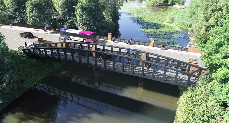
We will be introducing a major revamp of Leicester’s Abbey Park Road as part of our citywide programme of investment in sustainable transport, backed by £40million from the Department for Transport’s Transforming Cities Fund.
Improvements include a new bike-friendly footbridge across the River Soar, two e-bike docking stations, new bus lanes on both sides of Abbey Park Road, two additional pedestrian road crossings and improved footpaths to create a safer and more attractive route for pedestrians and cyclists.
The centrepiece of the scheme will be a new 3.5metre wide footbridge which will run parallel to the existing road bridge across the River Soar, helping to ensure that there is enough space for all road users to use the busy route safely.
Extensive maintenance work will also be carried out to the two existing road bridges which cross the river and canal.
New camera-enforced bus lanes running in both directions will give more priority to public transport in a bid to improve journey times and encourage more people to use the bus. Removal of the parking bays and filter lane to the park from the eastbound carriageway is required to accommodate this. Although general traffic will be reduced to one lane in either direction, the scheme has been designed to ensure that traffic capacity will be maintained, avoiding additional delays and congestion.
A small area of car parking immediately in front of the main gates into Abbey Park will be removed, and the area revamped to create a more welcoming approach into the park. A separate statutory process will be undertaken to introduce the removal of the parking bays here and along Abbey Park Road.
Initial works on the new footbridge on Abbey Park Road began in September 2021 and the footbridge is due to be completed in Spring 2022.
In addition to the above works, essential extensive maintenance work on the Abbey Corner Bridge is also scheduled to start from 31 March 2022 and will require an extended road closure for approximately 11 months.
A detailed survey of the historic bridge, which dates back to 1878, has found evidence of corrosion in the cast iron structure and other issues which require extensive maintenance to ensure that the bridge can continue to be used safely by heavy traffic.
As part of the repairs to Abbey Corner Bridge, the existing cast iron balustrade panels will be removed for full restoration, and the bridge parapet – or barrier – will be raised by around 30cm to improve safety.
The bridge maintenance and repairs have been programmed to take place during the Abbey Park Road. This will reduce the need for additional highway works on this busy route in the near future.
The essential bridge maintenance and repairs have been programmed to take place at the same time as planned highway improvement works on Abbey Park Road. Doing these works at the same time will avoid the need for further disruptive closures of the bridge and road for the foreseeable future.
Access will be maintained for residents and businesses and people visiting Abbey Park during the works.
Details of the diversion route can be found below. During the works, disruption will be kept to a minimum and access will be maintained to all properties.
- Artist impression of the new pedestrian/cycle footbridge (JPEG)
- Artist Impression of the highway works on Abbey Park Road (JPEG)
- Plan of Abbey Park Road works (PDF)
- Diversion route (PDF)
Bus services
All services that currently serve Abbey Park Road have registered to divert in both directions via Abbey Lane, St Margaret’s Way, Burleys Way and Belgrave Circle.
Service effects as follows:
- Centrebus: 22C, 54A
- First: 25, 26, 54
We are planning to improve a 2.5km route on Blackbird Road, Parker Drive and Beaumont Leys Lane, to help encourage more people to make the shift to walking and cycling.
The work will be paid for through the Transforming Cities Fund following our successful bid to support improvements to public transport and providing more safer cycling and walking routes into city neighbourhoods and the city centre.
The improvements are proposed on Blackbird Road, Parker Drive and Beaumont Leys Lane (between the A6 and Beaumont Walk). The proposed alterations are aimed at making improvements for pedestrians and cyclists by introducing cycle lanes and new/enhanced pedestrian and cycle crossing facilities.
Introducing pedestrian priority and cycle infrastructure will help encourage active modes of travel and hence reduce the reliance of the private car, particularly for short distance journeys. Plans showing the proposals have been attached to this letter. A plan showing the improvements along the route can be found below and can be summarised as follows:
- Convert the existing footway on the west side of Blackbird Road (The Blackbird Pub side) to a 3.0m joint use footway/cycleway between Buckminster Road and Parker Drive.
- Alterations to side roads to raise the level for pedestrians and cyclists through the junction.
- Introduce a segregated footway (2.0m)/cycleway (min 2.5m) on the west side (Somerset Avenue side) of Parker Drive.
- Alterations to the Parker Drive/Somerset Avenue junction to remove the left in and left out filter roads and to introduce improved pedestrian and cycling routes through the junction.
- Access to residential driveways at the Somerset Avenue junction to be amended in consultation with property owners.
- Alterations to the remaining side roads on the west side of Parker Drive to raise the level for pedestrians and cyclists through the junction.
- Convert the existing footway on the south side (petrol station side) of Beaumont Leys Lane between Parker Drive and Beaumont Walk to an approximately 2.5m joint use footway/cycleway.
- Convert the existing zebra crossing (between Halifax Drive and Parker Drive) to a parallel crossing to provide a separate crossing facility for cyclists.. This will require the removal of three trees adjacent to the existing crossing. Convert the existing footway on the north side of Beaumont Leys Lane between Parker Drive and the existing zebra crossing adjacent to Wolsey House Primary School to a 3.0m joint use footway/cycleway.
- Introduce a segregated footway (2.0m)/cycleway (3.0m) on the north side of Beaumont Leys Lane between the existing zebra crossing adjacent to Wolsey House Primary School and the A6. This will require the removal of two trees.
- Alterations proposed at the A6/Beaumont Leys Lane/Corporation Road junction to improve the crossing facilities for pedestrians and cyclists by renewing the traffic signal control equipment.
- As shown on the attached plans, eight trees will need to be taken out along the entire route to facilitate the scheme. However, we will aim to replace any lost trees on a 2 for 1 basis in close proximity of the lost trees.
The improvements are planned to commence on a phased basis from May 2022 and we aim to have the work complete by this Winter.
If you have any queries or comments on this scheme, please write or email to:
Pravin Godhania, Transport Strategy, Leicester City Council, City Hall, Leicester, LE1 1FZ
Email: [email protected]
This will require the number of lanes for general traffic to be reduced from two to one adjacent to the new bus lanes. The scheme has been designed so the new bus lanes will not adversely affect the general flow of traffic.
This includes a ‘No Stopping Order’ - commonly known as a red route. This will help prevent unauthorised parking (particularly by car transporters) which can be a significant cause of congestion along the route. Camera enforcement of the bus lanes is also proposed.
A new 30mph speed limit would be introduced between Thurcaston Road and the city centre to help manage traffic and make the route safer.
Provision for loading will be provided where needed to ensure that businesses are not affected. The proposed scheme would also see improvements made to the busy junction of Corporation Road, Beaumont Leys Lane and the A6, with safer pedestrian and cycle crossings introduced. New cycle lanes will be created on Beaumont Leys Lane linking to improvements already underway in that neighbourhood.
The works are likely to begin in spring 2023 and will also include general maintenance and any required resurfacing along the busy route. The existing inbound bus lane between Redhill Circle and Thurcaston Road will be retained. The improvements can be summarised as follows:
- Amendment of the existing inbound bus lane between Red Hill Circle and Thurcaston Road.
- The introduction of sections of new inbound and outbound bus lanes between:
- Thurcaston Road and Corporation Road.
- Wolsey Street and Sanvey Gate.
- The introduction of bus lane camera enforcement.
- The introduction of a No Stopping ‘red route’ on the A6 Abbey Lane/St Margaret’s Way between Red Hill Circle and the inner ring road to help manage parking and improve enforcement.
- The reduction in speed limit from 40mph to 30mph on the A6 Abbey Lane/St Margaret’s Way between Thurcaston Road and the existing 30mph speed limit close to the city centre. The reduced speeds will help make the area feel less car dominated and benefit more vulnerable road users such as pedestrians and cyclists.
- Junction improvements to the pedestrian and cycle crossings at the A6 Abbey Lane/Beaumont Leys Lane/Corporation Road junction.
- Removal of two trees on the A6 Abbey Lane adjacent to Corporation Road. The roots of these trees have lifted the footway which, have become a trip hazard. They are also starting to damage the kerbs and carriageway. The trees will be replaced on a two-for one basis.
- To improve the management of traffic a Variable Message Sign on the inbound side of the A6 Abbey Lane is being proposed. The exact location is still to be confirmed.
- General maintenance work to the A6 Abbey Lane/St Margaret’s Way between Red Hill Circle and Sanvey Gate to repair any surface defects and to refresh any signing and lining as necessary.
- A new off-carriageway cycle lane on Beaumont Leys Lane between the A6 Abbey Lane and the entrance to Wolsey House Primary School. This new cycle facility will provide a link to the new cycle lanes on Parker Drive and the rest of Beaumont Leys Lane.
Our appointed contractor will be in contact with you nearer to the start of the works to discuss and confirm if any temporary access arrangements for deliveries will be required whilst the improvement work is carried out.
View maps detailing proposed works (PDF)
We are now planning to make improvements to the A607 Melton Road between Sandringham Avenue and Troon Way. A plan showing the improvements on the A607 Introduction of new outbound bus lane between Sandringham Avenue and Troon Way.
- Extend the existing inbound bus lane to cover the length between Troon Way to Glencoe Avenue.
- Alterations to the toucan crossings at the A607 Melton Road/Lanesborough Road roundabout.
- Introduction of bus lane camera enforcement.
We will also be undertaking the following as part of the works on the A607 Melton Road.
- The reduction in the number of lanes for general traffic supports the need for a reduced speed limit on the A607 Melton Road between the city/county boundary and the existing 30mph speed limit. The reduced speeds will help make the area feel less car dominated and benefit more vulnerable road users such as pedestrians and cyclists.
- The installation of a LED Variable Message Sign on the inbound side of the A607 Melton Road at the Humberstone Lane junction.
- General maintenance work to the A607 Melton Road between Lanesborough Road and Troon Way to repair any surface defects and refresh signing and lining.
- Introduction of new bus stops comprising real time bus information.
- Maintenance items on the A607 Melton Road (between Sandringham Avenue and Troon Way).
The improvements are planned to commence on a phased basis this autumn and we aim to have the work complete by the Spring 2022.
We were recently awarded funds from the Department for Transport’s Transforming Cities Fund to deliver a series of pedestrian, cycling and public transport improvements in the north west and south west of the city. The package of work will focus on major sustainable transport improvements to provide attractive choices for people to access places work, education and other facilities whilst supporting the city’s growth and delivering on the council’s climate emergency, air quality and healthy living commitments. As part of this programme, transport improvement works are planned for Anstey Lane and Buckminster Road:
Anstey Lane
This scheme will include:
- A new bus lane on Anstey Lane between Buckminster Road and Blackbird Road to improve journey times
- A new shared 3m cycleway on the south footway between Buckminster Road and Avebury Avenue (meets with existing shared cycleway on the footway in front of English Martyrs School).
- A new shared 3m cycleway/footway on Anstey Lane between Great Meadow Road and Darenth Drive (meets with existing cycle facilities on the footway up to Krefeld Way).
- Raised tables at side roads and a new pedestrian crossing to create a safer route.
- The removal of three trees will be required to enable these improvement works. We will replant six trees nearby in a more suitable location.
Buckminster Road
We will be introducing an experimental closure of Buckminster Road between Brading Road and Anstey Lane to prevent the road from being used as a ‘rat run’, and to create a safer route for pedestrians and cyclists, as well as providing a quieter and more attractive area for residents. Access for pedestrians and cyclists will remain unchanged.
There will the opportunity for people to comment during the first six months of the experiment, after which the scheme will be reviewed. The council would only consider adopting a permanent scheme following consideration of comments received during the experimental scheme together with analysis of any relevant survey information gathered. To have your say on the experimental Traffic Regulation Order process, look out for notices in the local area and in local media.
Plans, programme, traffic management and diversions
The proposed plans for the works can be seen above.
The improvements are planned to commence on a phased basis from June 2021 for approximately six months.
Please see below for diagrammatic plan of proposed phasing and closures.
Please note that some bus routes will be affected by the works as follows:
First Bus Service 74
- Inbound will be via Avebury Avenue/Somerset Avenue/Parker Drive/Blackbird Road/Ravensbridge Drive for Phase 1 inbound.
- Outbound route as normal. Some stops may be re-positioned.
Centrebus Service 154
- Inbound will be via Somerset Avenue/Parker Drive/Blackbird Road/Ravensbridge Drive for Phase 1.
- Outbound route as normal. Some stops will be re-positioned.
We are going to upgrade Beaumont Walk and Lismore Walk to ensure these routes are well-connected, accessible and safe for pedestrians and cyclists. The existing path will be widened and resurfaced. Street lighting and signage will also be renewed, where required.
Works will be carried out in phases to minimise disruption, but this means that sections of the path will be closed. Appropriate diversion routes for cyclists and pedestrians will be in place. The first phase of works between Beaumont Leys Lane and Calder Road have been completed. Works will now continue along the next section of the route from Calder Road to Bishopdale Road.
Works have also commenced to remove the Lismore Walk underpass beneath Strasbourg Drive. The underpass will be filled in and the area will be re-landscaped to create new shared footpaths and cycle routes to the north and south of Strasbourg Drive. A new parallel zebra crossing will also be installed. The works are expected to take 4 months to complete.
The scheme is part funded by the Department for Transport Transforming Cities Fund.
We are planning to improve a part of Saffron Lane to help encourage more people to make the shift to walking and cycling.
The planned scheme will see a new permanent cycle track created on a busy stretch of Saffron Lane, between Heathcott Road and its new junction with Putney Road.
A new three-metre-wide cycle lane will also be provided across Aylestone Recreation Ground, alongside the existing tree-lined footpath through the park.
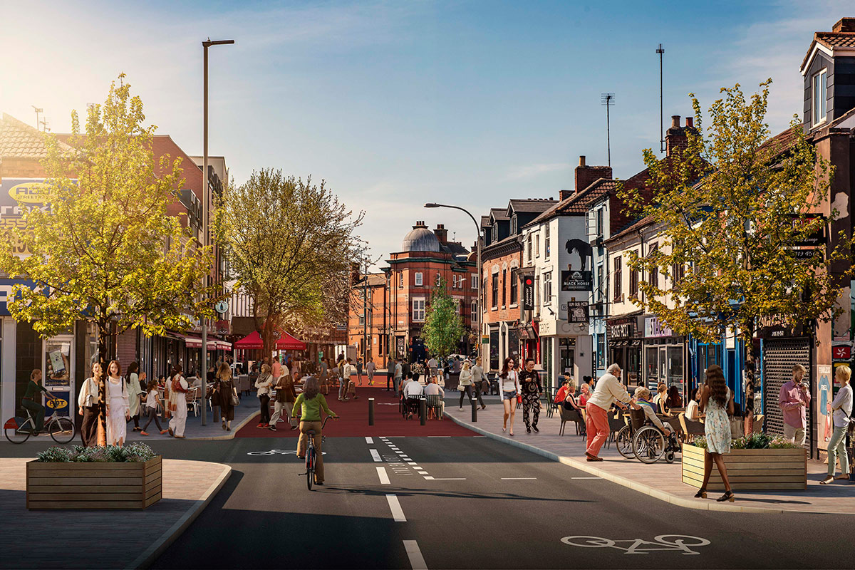
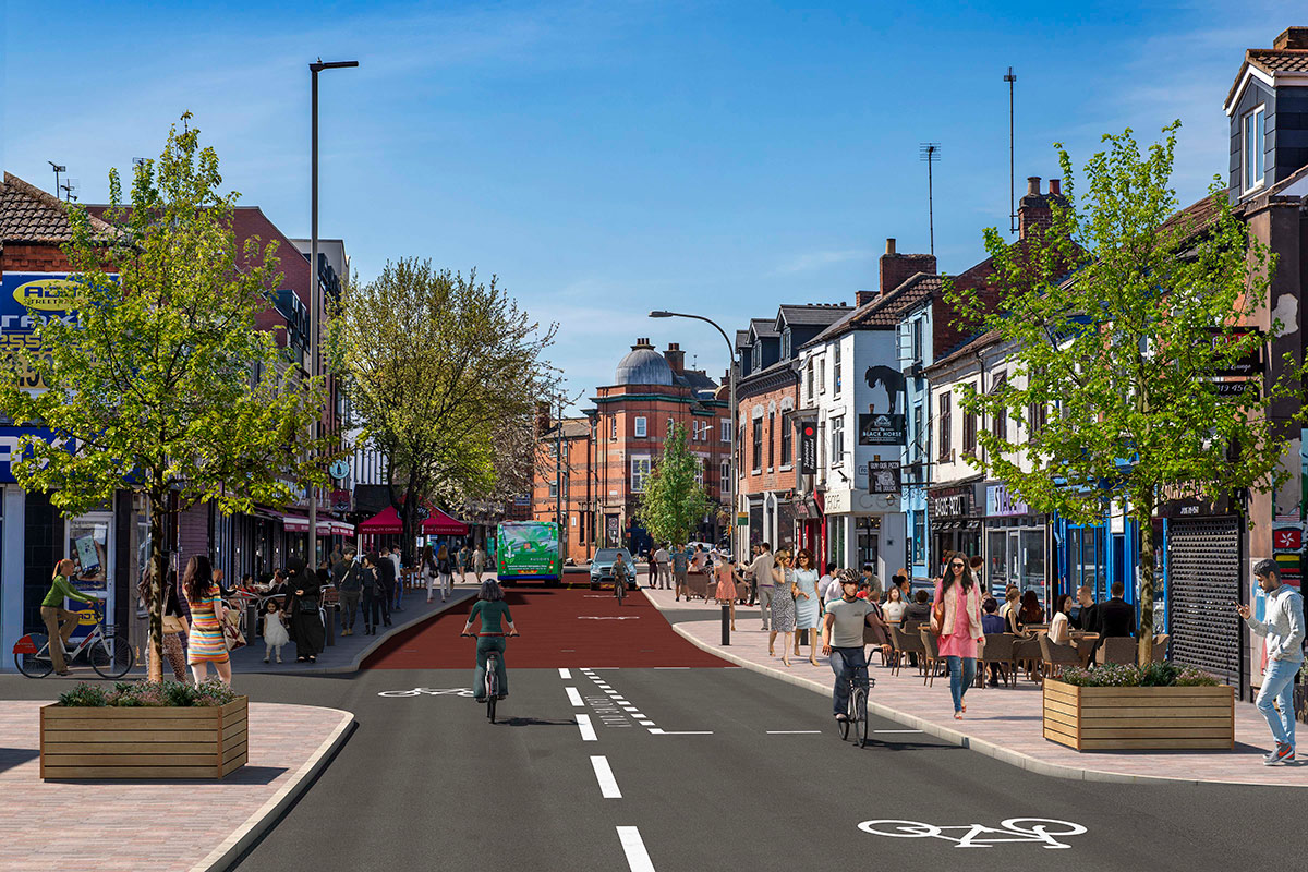
- Traffic from Duns Lane and New Park Street will be restricted to buses, cycles and taxis, easing congestion and creating a cleaner, safer high street.
- Pavements on Braunstone Gate will be widened and improved, with high-quality block paving installed in the central section of Braunstone Gate, prioritising pedestrian use and providing a more attractive environment.
- Red asphalt will be used to surface the carriageway, denoting Braunstone Gate’s status as a ‘mini-Holland’ and further enhancing the appeal of the street.
- New trees will be planted, making the street more attractive.
- Local businesses will be able to apply for street café licences and on-street seating, creating a vibrant, continental feel.
- A new cycle hub will be installed on Braunstone Gate, encouraging sustainable, healthy travel.
- Left-turn access from Western Boulevard will be closed to all users except cyclists, creating a safer route into Braunstone Gate.
- On-street parking will be removed (disabled parking provision will be retained, as will loading bays for local businesses).
- Subsequent phases of the scheme could see access closed to buses on Friday and Saturday evenings, in order to encourage al fresco dining and entertainment, and further enhance the street’s night-time economy.
We are planning to invest in the region of £2m to improve pedestrian, cyclist and public transport facilities to help encourage more people to make the shift to walking, cycling and public transport.
As part of the proposed scheme for Aylestone Road:
We aim to provide new and improve existing pedestrian and cycle facilities from Putney Road to Welford Road.
The existing footway between Putney Road and Almond Road will be widened to up to three metres to create a new segregated footway/cycleway.
In addition, we are proposing to provide a segregated footway/cycleway; making the current temporary cycle lane from Almond Road to Welford Road permanent by removing the offside (coned off) lane. Furthermore, the council aims to provide an additional cycle link from Welford Road to Lancaster Walk by providing a segregated cycle lane with the removal of the bus lane to accommodate widening into the carriageway.
Raised tables and new and improved signals will be installed, to provide a safer route for pedestrians and cyclists.
Work is due to begin in Spring 2022.
You can see plans for this scheme in the PDFs below:
Help with documents
PDFs published on this page are intended to be printed. If you have problems accessing or viewing any of the documents, please email [email protected].